Pensacola Discussion Forum
Would you like to react to this message? Create an account in a few clicks or log in to continue.

This is a forum based out of Pensacola Florida.


You are not connected. Please login or register

The first worrisome storm of the season is now here

+6
Hallmarkgard
dumpcare
Sal
RealLindaL
2seaoat
Hospital Bob
10 posters

Go to page : Previous  1 ... 5 ... 7, 8, 9 ... 17 ... 26  Next

Go down  Message [Page 8 of 26]

dumpcare


Bob wrote:If it does fizzle out,  I think it'll be very much out of the ordinary for a storm to exist this long at low latitude and then just dissapate.  But this is a year of the unusual so I guess it's to be expected.
 

You're right, wasn't Ivan a little lower? Under Cuba or did it go over? Can't remember.

Bob, you know everything I've been going through, well woke up with no pain anywhere this morning, NONE. Then while leaving for work bent the right way and through my damn back out. It was lower but by the time I got of work my upper and neck are killing me. Damn I can't get a break. I just couldn't believe it. Someone I work with says I need to go to Church lol.

Joanimaroni

Joanimaroni

The only hurricane I evacuated to Pensacola for was Fredrick. Unless it is a Cat 5....I will stay home.

Hospital Bob

Hospital Bob

ppaca wrote:

Bob, you know everything I've been going through, well woke up with no pain anywhere this morning, NONE. Then while leaving for work bent the right way and through my damn back out. It was lower but by the time I got of work my upper and neck are killing me. Damn I can't get a break. I just couldn't believe it. Someone I work with says I need to go to Church lol.

It's a worn out phrase but it bears repeating. Getting old is a bitch.

Hospital Bob

Hospital Bob

ppaca wrote:


You're right, wasn't Ivan a little lower? Under Cuba or did it go over? Can't remember.


Ivan set 18 hurricane records.  Three of them were the fact that it was at the lowest latitude of any hurricane when it was at cat 3,  the lowest latitude to be a cat 4,  and the lowest latitude to be a cat 5.

And at it's peak intensity,  it's the tenth most powerful of all Atlantic hurricanes on record.

It also has the 2nd highest ACE classification of all Atlantic hurricanes...

https://en.wikipedia.org/wiki/Accumulated_cyclone_energy

The latter two are why I believe it seemed stronger than the ordinary category 3 storm at landfall.  It had been a monster hurricane and I think that made  it be a bitch at the end too.

Hospital Bob

Hospital Bob

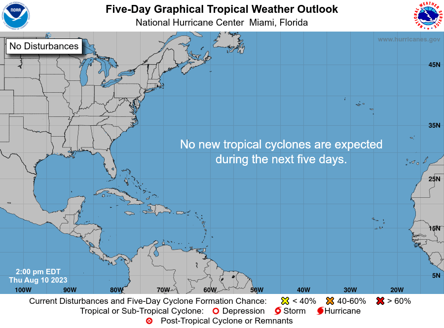
This might be encouraging. While they still have no official track forecast, at four days out the NHC has this cone curving westward. Which if it turns out to be the storm's actual path would be good news for us because it would be more likely to go further west than we're at here...

The first worrisome storm of the season is now here - Page 8 Two_atl_5d0

RealLindaL


Bob wrote:This might be encouraging.  While they still have no official track forecast,  at four days out the NHC has this cone curving westward.  Which if it turns out to be the storm's actual path would be good news for us because it would be more likely to go further west than we're at here...

But that graphic doesn't show what happens next.  And the most recent runs of both the Euro and GFS, along with several of the spaghetti ensembles, now show the storm heading immediately northward after crossing into the Gulf through the Florida Straits or over the Keys, skirting along the west coast of the peninsula, then recurving through the Big Bend, skirting along the SE coast (GA,SC, NC) and back out to sea.  

In other words, stay tuned.

Hospital Bob

Hospital Bob

RealLindaL wrote:
Bob wrote:This might be encouraging.  While they still have no official track forecast,  at four days out the NHC has this cone curving westward.  Which if it turns out to be the storm's actual path would be good news for us because it would be more likely to go further west than we're at here...

But that graphic doesn't show what happens next.  And the most recent runs of both the Euro and GFS, along with several of the spaghetti ensembles, now show the storm heading immediately northward after crossing into the Gulf through the Florida Straits or over the Keys, skirting along the west coast of the peninsula, then recurving through the Big Bend, skirting along the SE coast (GA,SC, NC) and back out to sea.  

In other words, stay tuned.

Yep looks like that going west of us was wishful thinking on my part.
But if it doesn't get any further west than the Big Bend I'll take that too. lol

Hospital Bob

Hospital Bob

RealLindaL wrote:
Bob wrote:This might be encouraging.  While they still have no official track forecast,  at four days out the NHC has this cone curving westward.  Which if it turns out to be the storm's actual path would be good news for us because it would be more likely to go further west than we're at here...

But that graphic doesn't show what happens next.  And the most recent runs of both the Euro and GFS, along with several of the spaghetti ensembles, now show the storm heading immediately northward after crossing into the Gulf through the Florida Straits or over the Keys, skirting along the west coast of the peninsula, then recurving through the Big Bend, skirting along the SE coast (GA,SC, NC) and back out to sea.  

In other words, stay tuned.

What do you make of this...

The first worrisome storm of the season is now here - Page 8 28u1dg3

dumpcare


Somebody is smoking some good stuff or this Monday they will all come together around Mobile to Destin.

I was watching weather channel about 2 hours ago and Stephanie was explaining why EURO was better than GFS but a come close together in a couple days before landfall. GFS is American she said and they don't put as much money into their systems where the EURO has deep pockets.

So which color is the euro in this pic?

Hospital Bob

Hospital Bob

ppaca wrote:

So which color is the euro in this pic?

That's a DAMN GOOD question, ppaca. I've been looking at that spaghetti for days now wondering where both the euro and the GFS are supposed to be on it.

That run was initialized at 12 zulu time. But here's one from 6 hours earlier for the GEFS. The GEFS is closely related to the GFS. That track is derived from an ensemble of 21 different forecast models.
As you can see, this spaghetti is quite a bit different than the last one I posted.
I think I'm gonna ignore all these chicken tracks and let the NHC interpret it all for me. lol

The first worrisome storm of the season is now here - Page 8 35lxfuq

dumpcare


They just showed the euro on weather channel they have it coming off the west coast at around Naples or just a little below but did not go beyond that.

I don't know if storm2k, the weather channel and Bastardi knows something the general public doesn't but they are sure playing this up. Bastardi thinks this will be a 3 in the GOM as storm2k. The wc is playing it safer in the that respect and just telling everyone basically to beware.

Hospital Bob

Hospital Bob

If it either goes through the Florida Straits or low over the peninsula and then gets in the Gulf,  that's when things could quickly change.  Many storms have undergone rapid intensification in the southern gulf and often it's not in the forecast.  Hurricane Charley in 2004 was a good example.

Hospital Bob

Hospital Bob

Same thing happened with Katrina the following year.  It crossed over Florida and once in the Gulf it went from a minimal storm to category 5.

The first worrisome storm of the season is now here - Page 8 Images?q=tbn:ANd9GcQsvChuEQ0sL7aTj_5dyzlAnsGvGyqCFR_cAcWln5UOSquLHjs2XQ

dumpcare


http://www.storm2k.org/phpbb2/viewtopic.php?f=59&t=118167&start=2900

scroll down to the last post with the 3 second video.

Hospital Bob

Hospital Bob

ppaca wrote:http://www.storm2k.org/phpbb2/viewtopic.php?f=59&t=118167&start=2900

scroll down to the last post with the 3 second video.

Not good.

Hospital Bob

Hospital Bob

BUT, here's where the latest run of the ECMWF ("euro") has it on Wednesday.
Whereas that animation had it going into Louisiana next week.

CONCLUSION: Still too far away yet for any of these models to know where it's going.


The first worrisome storm of the season is now here - Page 8 Efa1a0d719

2seaoat


This technique is beginning to be recognized as the best predictive model.....

Hospital Bob

Hospital Bob

2seaoat wrote:This technique is beginning to be recognized as the best predictive model.....


Yes when the storm is this far away from us it would be like throwing darts to predict where it will go.  That's why you don't see the National Hurricane Center attempting to throw those darts.  
So you've created a strawman.

Hospital Bob

Hospital Bob

The NHC focuses on a 3 day track forecast (they also provide a graphic for 5 days but they warn us about the large margin of error in that).

Remember what I told you way back in this thread.  Today's average error in the track forecast 3 days out is 115 miles.

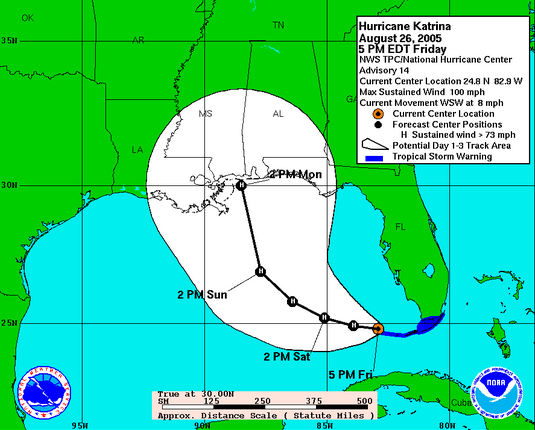
Let's take a look at Katrina.  This is the NHC track forecast for Katrina when it was 3 days from landfall.  As you can see, they had the center of the storm coming into Mississippi and the forecast WAS WITHIN that margin of error (of where the center actually did make landfall).
That is ALL they're telling us they can do,  2seaoat.  That's the current state of the art in hurricane forecasting.  The current state of the art IS NOT being able to tell you a storm is going to strike Escambia County when the fucking thing is more than 1000 miles away from us.

The first worrisome storm of the season is now here - Page 8 Kat10

2seaoat


No strawman Bob.....rather a horrible profit motive is driving the weather these days. Internet clicks and tv viewership go through the roof when one peddles terrible weather. An example in Illinois by all three of the internet weather services. A few weeks back Texas was having severe storms, but when you clicked on weather for Northern Illinois, at the bottom of the page was the red and orange of texas storms and a prediction for weekends that there was a 40% chance of rain which had a storm cloud with raindrops falling on the graphic. When the average person looks at that page and was planning a golf outing that weekend, people begin to cancel plans. The reality that weekend was that it was bone dry and people clicked on the weather link and watched the local news weather to find out if that orange and red was coming........the key here is that there was zero cause and effect of the Texas storms and Illinois weather that weekend except to create the illusion of threat which had people checking the weather.

There is talk across America among outdoor recreation business associations of filing a class action against the intentional over statement of threat to profit when clearly the graphics and wording create the illusion of weather threat which requires changes in weekend plans. If you think that folks do not profit from hurricane forecasting and the captured audience, then your strawman is valid.....reality has shown something quite different. It is darts which allows higher viewership under the illusion that these models five days out are anything but darts....not science which has the the tenets of science which is repeated high percentage success in forecasting a specific outcome.

Hospital Bob

Hospital Bob

2seaoat wrote:No strawman Bob.....rather a horrible profit motive is driving the weather these days.   Internet clicks and tv viewership go through the roof when one peddles terrible weather.

That's why I've always preached that you should ignore the National Hurricane Center and get all your hurricane information from Jim Cantore,  the greatest meteorologist of them all.  And if you don't believe that just ask him.
And you can do that if the hurricane comes here. He'll be out there on the beach telling the rest of us not to be there.

Hospital Bob

Hospital Bob

I've told this story before but this is a good time to tell it again.

About 3 years ago a little storm was coming our way so my friend (you'll remember him as yelladawg) and I went out to the Hilton on the beach to watch the waves.
After we'd seen the waves,  we walked back through the hotel on the way to the parking garage.

As we got to the elevator we did a double take when we saw this guy standing there.  It took me a while to recognize him because he's about a foot shorter than he looks on tv.
But yelladawg actually thought he recognized him as an old friend from Texas and started talking to him as if he were that.
And that's when Jim Cantore really acted ugly toward us.  It must have totally deflated his ego when someone didn't know who he was.  It was a hoot.  lol

2seaoat


It will take litigation, but in the meantime our economy suffers billions of dollars of damage to the outdoor recreation sector, and with Hurricanes.....people die. Just like the epi pen, these corporate CEOs see life or death weather forecasting as a path to profit.

Hospital Bob

Hospital Bob

Of course they do. Exactly as the corporate media does.

But see that's why I don't rely on corporate tv of any kind (weather or news or wrestling or whatever) to give me anything except a profit driven perspective. And if I was to rely on that, I'd always rely on the judgement of any car salesman who tells me his car is better than the competition.

stormwatch2016


Bob, you know my moniker. Been there too many times.
.
Please all, make sure your inventories are up to date. That is the only way you'll survive financially

Sponsored content


Back to top  Message [Page 8 of 26]

Go to page : Previous  1 ... 5 ... 7, 8, 9 ... 17 ... 26  Next

Permissions in this forum:
You cannot reply to topics in this forum