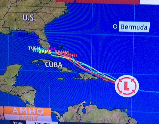
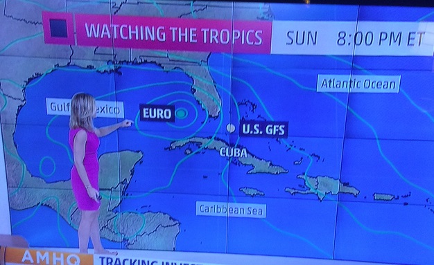
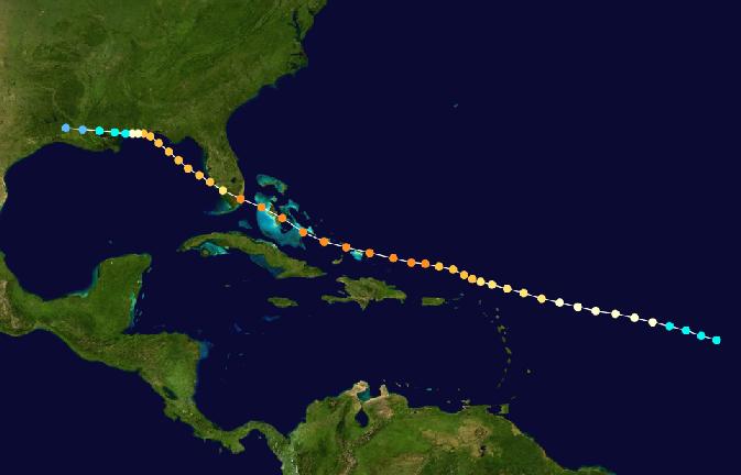
Pensacola Discussion Forum
Would you like to react to this message? Create an account in a few clicks or log in to continue.

This is a forum based out of Pensacola Florida.


You are not connected. Please login or register

The first worrisome storm of the season is now here

+6
Hallmarkgard
dumpcare
Sal
RealLindaL
2seaoat
Hospital Bob
10 posters

Go to page : Previous  1 ... 6, 7, 8 ... 16 ... 26  Next

Go down  Message [Page 7 of 26]

2seaoat


Then why did you insist that I tell you when it will hit Pensacola? lol


Because I need to drive my one ton truck down to move my RV from a flood zone and I have a bad pump on one of my gas tanks which means I will stop for gas 15 times coming to Pensacola to move the RV to storage. So three days would be nice....one day to get there and move it to high ground, and one day to get the hell out of there........so you see Bob, I do not need darts.....I need you to put your tommy skillethead hat on and make some sense......right now I do not feel well, and have a doctor's appointment on the 7th which I cannot miss because things are not good, so you better not let me down........three days......fifty miles, and bam my dump truck hits the road.

dumpcare


Well oatie if by chance it should hit here it will be next Tuesday or Wednesday.

Ok here is a copy and paste from wxman57 and professional who has been pretty accurate for years. I will post the whole link to read discussion.

wxman57 wrote:
This could well be a hurricane threat to south FL and a major hurricane threat to the mid Gulf Coast. More EC ensembles are on-board with development and most indicate a track into the Gulf. Final landfall may be around next Tuesday night, quite possibly west of the FL Panhandle and east of Houston (I hope). I guess I'll have to cancel my vacation days for this Thu/Fri. I knew 2 weeks ago when I scheduled them that I'd make the tropics come alive in doing so. It always happens...

http://www.storm2k.org/phpbb2/viewtopic.php?f=59&t=118166&start=820

But still has a chance to do nothing. I would move my RV regardless.

2seaoat


I have grandkids birthdays this weekend and I have to be here for the labor day weekend with my shots and Dr. appointments......I got to hope this will not manifest itself in the time frame you outlined.

Joanimaroni

Joanimaroni

Yikes....i'll be in Boston.

Hospital Bob

Hospital Bob

Before we conclude it's gonna hit P'cola, give it at least a few more days. lol

dumpcare


Oh I know these models and discussion are etched in concrete, anything can happen and it may not even develop.

RealLindaL


Bob wrote:Before we conclude it's gonna hit P'cola,  give it at least a few more days.  lol

Of course you're right, Bob, though the models have definitely shifted back to the south now, indicating a more likely entry into the Gulf at some point, whether or not after crossing a piece of the peninsula.  This is getting a little nerve-wracking, especially as my husband has three important doctors' appointments next week.  

But there's never a good time for a hurricane.  None of us needs this.

Still hoping for the best, but if this large storm has enough strength trekking across the Gulf, even if not directed right at us we would likely have to evacuate the island due to surge threat, same as we had to do for Katrina.

I hope Sea can arrange for someone else to move his RV if it comes to that, and that Joani can button up her property as needed before leaving for Boston.  

Getting a bit more concerned here now, but trying not to let the stress overtake.  The models will swing back and forth numerous more times, especially if/when the C of C is defined, but anything entering the Gulf at a central or northerly latitude, if it has any chance of intensifying beyond tropical storm status, will almost surely mean evacuation.   {{{deep breaths}}}

2 a.m. 08/24 NHC estimated area of TC development next five days, with chance of development during the period now at 70%:

The first worrisome storm of the season is now here - Page 7 Two_atl_5d0

Hospital Bob

Hospital Bob

The latest ECMWF run.  This has the storm making landfall on the Louisiana coast next Thursday (Sep 1) as a category 3 hurricane.
Remember,  this forecast is 8 days out so should be taken with a several grains of salt...

The first worrisome storm of the season is now here - Page 7 FQhJRBD

These are screenshots from the 4AM Weather Channel report...

The major computer models are tightening...

The first worrisome storm of the season is now here - Page 7 Models10

This is showing where the two major track models have the storm on Sunday.  Notice the GFS has the storm moving slower than the ECMWF.

The first worrisome storm of the season is now here - Page 7 Sunday11

So far the path of this storm is similiar to the track of the 1926 hurricane which wiped out Miami and then Pensacola...

The first worrisome storm of the season is now here - Page 7 192610

Hospital Bob

Hospital Bob

The path of Hurricane Rita in 2005, the most intense hurricane ever observed in the Gulf of Mexico.  When the storm was about 4-500 miles below us in the Gulf, the central pressure was 895 mb with sustained winds of 180 mph.

The first worrisome storm of the season is now here - Page 7 2lllhma

dumpcare


If, and it does look like it will make it to the gulf the very warm waters will blow this up and could be devastating to La or anyone from Destin to Houston. Hope it doesn't come here we cannot evacuate like we have in the past.

dumpcare


Bastardi thinks this will be a big problem for the gulf in this thread

http://www.storm2k.org/phpbb2/viewtopic.php?f=59&t=118166&start=1120

run after run of the euro shows major hurricane in the gulf

http://www.storm2k.org/phpbb2/viewtopic.php?f=59&t=118167&start=2520

Hospital Bob

Hospital Bob

ppaca wrote:If, and it does look like it will make it to the gulf the very warm waters will blow this up and could be devastating to La or anyone from Destin to Houston. Hope it doesn't come here we cannot evacuate like we have in the past.

By the time it gets to the Florida peninsula or somewhere near that (maybe in the Florida Straits), I think we'll have a pretty good idea how close it will get to us.

Hospital Bob

Hospital Bob

11:35 AM Eastern from the NHC...

Updated: An Air Force Reconnaissance aircraft currently
investigating the broad low pressure area and tropical wave near
the northern Leeward Islands has found winds to tropical storm force
in a few squalls near the northernmost Leeward Islands.

dumpcare


Bob wrote:11:35 AM Eastern from the NHC...

Updated:  An Air Force Reconnaissance aircraft currently
investigating the broad low pressure area and tropical wave near
the northern Leeward Islands has found winds to tropical storm force
in a few squalls near the northernmost Leeward Islands.

Yes winds at 57, the mets on that storm board don't know why they haven't called TS. Some models have shifted a bit to big bend but EURO still about the same. They're worried it will blow up to a Katrina once it passes over Florida. If anything it is wise to get gas before Saturday, once in the Gulf oil rigs shut down and prices go up.

Sal

Sal

It's going to have to really come together pretty quickly if it's going to become a serious threat.

It's looking very disorganized at this point and may just fall apart.

Hospital Bob

Hospital Bob

The intensity models are never very reliable but let's hope they are in this case.  Because they have the thing at only category 1 as it approaches Florida.  

The best scenario is for a cat 1 storm to track across the peninsula at about the latitude of Sal's house.  A cat 1 won't be a big deal for Sal, and when it enters the Gulf it probably won't have time to do much intensification.

dumpcare


Bob wrote:The intensity models are never very reliable but let's hope they are in this case.  Because they have the thing at only category 1 as it approaches Florida.  

The best scenario is for a cat 1 storm to track across the peninsula at about the latitude of Sal's house.  A cat 1 won't be a big deal for Sal,  and when it enters the Gulf it probably won't have time to do much intensification.

It will probably fizzle out, nothing to worry about.

Hospital Bob

Hospital Bob

Well I have to admit, yours is an even better scenario, ppaca. Lol

dumpcare


Bob wrote:Well I have to admit,  yours is an even better scenario, ppaca.  Lol

I really don't believe though. This is my thoughts, coming of the coast of Fl as a 1, warm gulf waters blowing it up to a strong 3 before it hits somewhere between PC and the border of Texas.

dumpcare


I haven't seen a post from oats today, suppose he's on his way down here to move is RV?

RealLindaL


ppaca wrote:
Bob wrote:Well I have to admit,  yours is an even better scenario, ppaca.  Lol

I really don't believe though. This is my thoughts, coming of the coast of Fl as a 1, warm gulf waters blowing it up to a strong 3 before it hits somewhere between PC and the border of Texas.

The 12z Euro flipped from its immediate prior stance of a Cat 3 storm heading into Louisiana to a minimal 'cane (75 mph) hitting Apalachicola. I see very little value in getting excited about any models or track predictions at least until there's a defined center of circulation, which the Hurricane Hunters failed to find today despite tropical storm force winds in squalls.

2seaoat


no....health issues today. I am concerned for the folks in La....I sure do not want a hit, but more rain on top of what they are facing now.....I have another place to live, and I have already 250k in hits from floods and storms....what are a few more dollars with so little time....I would prefer it dissipates, but my good fortune can be another person's life somewhere else. I could not get flood insurance for the rv and I have 45k invested, but my health is going to prevent me from doing much.....a mild surge no problem.....anything over four feet in escambia bay and I am screwed.

dumpcare


RealLindaL wrote:
ppaca wrote:
Bob wrote:Well I have to admit,  yours is an even better scenario, ppaca.  Lol

I really don't believe though. This is my thoughts, coming of the coast of Fl as a 1, warm gulf waters blowing it up to a strong 3 before it hits somewhere between PC and the border of Texas.

The 12z Euro flipped from its immediate prior stance of a Cat 3 storm heading into Louisiana to a minimal 'cane (75 mph) hitting Apalachicola.   I see very little value in getting excited about any models or track predictions at least until there's a defined center of circulation, which the Hurricane Hunters failed to find today despite tropical storm force winds in squalls.

No one's getting excited Linda, but I certainly would fill up with gas before the weekend because if it does go into the gulf they will shut down all the rigs and raise the prices along the coast.

dumpcare


Just watching the beach renourishment is almost finished.

Hospital Bob

Hospital Bob

If it does fizzle out, I think it'll be very much out of the ordinary for a storm to exist this long at low latitude and then just dissapate. But this is a year of the unusual so I guess it's to be expected.

Sponsored content


Back to top  Message [Page 7 of 26]

Go to page : Previous  1 ... 6, 7, 8 ... 16 ... 26  Next

Permissions in this forum:
You cannot reply to topics in this forum