Pensacola Discussion Forum
Would you like to react to this message? Create an account in a few clicks or log in to continue.

This is a forum based out of Pensacola Florida.


You are not connected. Please login or register

The first worrisome storm of the season is now here

+6
Hallmarkgard
dumpcare
Sal
RealLindaL
2seaoat
Hospital Bob
10 posters

Go to page : Previous  1 ... 5, 6, 7 ... 16 ... 26  Next

Go down  Message [Page 6 of 26]

Hospital Bob

Hospital Bob

2seaoat wrote:I will wait for you to make a prediction.  72 hours......use whichever model you wish........but there are storms right now.....tell us where they are going.  

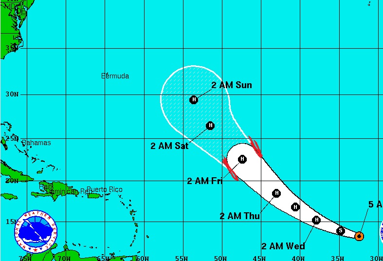
I predict that 72 hours from now, the center of Tropical Storm Gaston will be located between the 2 red lines I've added to this map.

The first worrisome storm of the season is now here - Page 6 Gaston10


dumpcare


99L today models and discussion

http://www.storm2k.org/phpbb2/viewtopic.php?f=59&t=118167&start=1880

http://www.storm2k.org/phpbb2/viewtopic.php?f=59&t=118167&start=1900

2seaoat


I predict that 72 hours from now, the center of Tropical Storm Gaston will be located between the 2 red lines I've added to this map.

Landfall Escambia County grad......landfall.......you know like when Pensacola was colonized before anywhere else......while those folks somewhere on the east coast wandered around........we need a location......I am beginning to see a pattern.

Hospital Bob

Hospital Bob

2seaoat wrote:I predict that 72 hours from now, the center of Tropical Storm Gaston will be located between the 2 red lines I've added to this map.

Landfall Escambia County grad......landfall.......you know like when Pensacola was colonized before anywhere else......while those folks somewhere on the east coast wandered around........we need a location......I am beginning to see a pattern.

This is exactly what you insisted that I predict, and I'm quoting...

I will wait for you to make a prediction. 72 hours......use whichever model you wish........but there are storms right now.....tell us where they are going.


So I gave you the prediction you asked for.

dumpcare


I tried uploading these pics earlier and didn't work and still won't but here is the latest run and predictions if you read completely down the page.

http://www.storm2k.org/phpbb2/viewtopic.php?f=59&t=118167&start=2060

If you read the discussion's it reminds one of mets of Katrina.

RealLindaL


As for me, I much prefer the National Hurricane Center:

http://www.nhc.noaa.gov/

dumpcare


And their graph has it coming across Florida so not any difference.

Hospital Bob

Hospital Bob

The first worrisome storm of the season is now here - Page 6 99L_tracks_latest

Hospital Bob

Hospital Bob

The first worrisome storm of the season is now here - Page 6 Storm_06

2seaoat


You can bet $500 that you can predict within fifty miles where the storm will hit landfall(we will define the center where the eye crosses land with a 25 mile east, and 25 mile west range.

An Escambia graduate picks a spot in the middle of the ocean.....splendid.

Hospital Bob

Hospital Bob

Now for the latest intensity model runs. But this is WAY less certain than what the track models tell us.

The first worrisome storm of the season is now here - Page 6 99L_intensity_latest

2seaoat


Bob....a serious question.......with all the colored options, is one color more historically accurate than another, and how would a person tuning into this information render the same down to something which is not pure dartboard?

Hospital Bob

Hospital Bob

When you're looking at the track model spaghetti,  keep in mind that in recent years the ECMWF (aka "european model") has proven to be the most reliable.
Followed by the GFS and GFDL.

The ECMWF out-performed the official NHC forecast in 2010 for 3-day and 4-day forecasts, and in 2009 for 4-day and 5-day forecasts.

2seaoat


Then would it not be a logical stance to show by color the predictive success of all these models which the orange one has it hitting North Carolina, and the black one is going to hit Texas........How is that science? How is it helpful to citizens who have to make a decision to prepare, and how is this information packaged to be a forecast tool. Pure dartboard, and when you talk to people who got whacked in Katrina, it was all the cries of wolf prior to Katrina which made them ignore Katrina. I remember on that Saturday night calling friends in Biloxi telling them to get the hell out, and they said "we are always being told we will be hit, and it never happens, plus my house survived Camille......"
Hospital Bob

Hospital Bob

The real problem is the best performing track model (ECMWF) is not made available for public viewing by the fucking Europeans.  Which means we can't see it except through Al Roker and those other assholes.
Or we can get hints of it from sources like this...

"What has changed somewhat in the past day is the fact that one of the best performing global models, the ECMWF, has begun developing 99L in the vicinity of the Bahamas and sends it in to Florida. Other models have followed such as the U.S. generated HWRF which did very well last season with Joaquin – once it formed.


But to answer your question directly, the NHC official track forecast is the thing to watch. It's derived from an ensemble of the best computers models.

2seaoat


Are the European modeling a result of more computing power and the use of super computers, programing, or luck? It seems to me that the idea of science is to share data and programs which improve forecasts. We can look at an Old Dick Tracy comic on Sundays in 1970 and see a wrist watch tv.....we thought it would never happen, and in 1970 the air force was launching planes to track hurricanes, and we were basically clueless. The technology has not matched in hurricane forecasting, yet anybody can get a wrist watch TV.

Hospital Bob

Hospital Bob

I forgot to put a link to the quote in my last post. It came from this page.
Read the whole page and you'll see that 99L is proving to be a tough one to forecast.

http://hurricanetrack.com/category/99l/

Hospital Bob

Hospital Bob

2seaoat wrote:Are the European modeling a result of more computing power and the use of super computers, programing, or luck?

It seems to me that the idea of science is to share data and programs which improve forecasts.  

in 2006 the ECMWF made a lot of improvements in many areas which made it the most reliable.

As to sharing data, I abolutely agree. But it's not limited to hurricane forecasting. If you've seen any of the interviews with Sean Parker concerning his interest in cancer research, he puts all the emphasis on the current failure of the major cancer centers to share information and data.

2seaoat


Bob.....they seem confused on 99L......I mean this nation has spent trillions over the last 100 years dealing with hurricanes, and we cannot develop a national urgency to get forecast tools which actually forecast?

RealLindaL


2seaoat wrote:Bob.....they seem confused on 99L......I mean this nation has spent trillions over the last 100 years dealing with hurricanes, and we cannot develop a national urgency to get forecast tools which actually forecast?

Peeps, we need to wait until and if there's a defined center of circulation for 99L. Until then, tracking will be all over the place. Happens all the time. You can't track a cyclone until it's a cyclone.

Hospital Bob

Hospital Bob

RealLindaL wrote:
2seaoat wrote:Bob.....they seem confused on 99L......I mean this nation has spent trillions over the last 100 years dealing with hurricanes, and we cannot develop a national urgency to get forecast tools which actually forecast?

Peeps, we need to wait until and if there's a defined center of circulation for 99L.  Until then, tracking will be all over the place.  Happens all the time.  You can't track a cyclone until it's a cyclone.

That's why you don't see the NHC providing a forecast track yet.

RealLindaL


ppaca wrote:And their graph has it coming across Florida so not any difference.

Across Florida -- how do you mean?

In any event, Bob's right, of course -- there's no official forecast track yet. The graphic is currently only a rough estimate.

The first worrisome storm of the season is now here - Page 6 Two_atl_5d0

Hospital Bob

Hospital Bob

This is what the NHC released at 1 PM our time...

Reports from an Air Force Reserve Hurricane Hunter aircraft indicate
that the tropical wave located a few hundred miles east of the
Lesser Antilles has an elongated and poorly defined circulation. In
addition, satellite imagery indicates that the associated shower and
thunderstorm activity remains disorganized. Environmental conditions
are only marginally conducive for development during the next couple
of days while the system moves west-northwestward at 15 to 20 mph
near the northern Leeward Islands and the Greater Antilles. Large-
scale conditions could become more conducive later this week while
the system moves nears the southeastern and central Bahamas. Another
Air Force Reserve Hurricane Hunter aircraft is scheduled to
investigate this disturbance tomorrow, if necessary. Interests from
the islands of the northeastern Caribbean Sea to the Bahamas should
continue to monitor the progress of this system. Gusty winds, heavy
rains, and possible flash floods and mud slides could occur over
portions of these areas regardless of tropical cyclone formation.
Please consult products issued by your local meteorological offices
for further details.
* Formation chance through 48 hours...medium...40 percent
* Formation chance through 5 days...medium...60 percent

2seaoat


I am absolutely confused when reading the comments where people are talking about it crossing florida and hitting the Gulf Coast but the last graphic could also have it heading north and not ever hitting land......it makes NO sense to me until it is just about 100 miles away.

Hospital Bob

Hospital Bob

2seaoat wrote:I am absolutely confused when reading the comments where people are talking about it crossing florida and hitting the Gulf Coast but the last graphic could also have it heading north and not ever hitting land......it makes NO sense to me until it is just about 100 miles away.  

Then why did you insist that I tell you when it will hit Pensacola? lol

2seaoat...

"Landfall Escambia County grad......landfall.......you know like when Pensacola was colonized before anywhere else......while those folks somewhere on the east coast wandered around........we need a location."

Sponsored content


Back to top  Message [Page 6 of 26]

Go to page : Previous  1 ... 5, 6, 7 ... 16 ... 26  Next

Permissions in this forum:
You cannot reply to topics in this forum