
 Latest images
Dear Precinct Leaders:
Both the Commissioner and I have been in touch with our Emergency Operations Manager and will be receiving updated information as it becomes known.
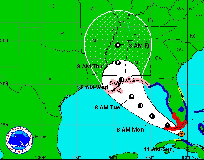
As of this moment, the latest forecast from the National Weather Service has Tropical Storm Isaac tracking East of Pensacola. This means that, again as of the latest forecast, Panama City Eastward will be in the crosshairs of Isaac. If this forecast remains there will be some minor storm surge from wind and rain from the outer bands. Additionally, the latest forecast indicates a slowing movement on the storm. In essence, it is to early to tell what T.S. Isaac will do. So, preparation is most certainly advisable. Please don’t take Isaac lightly. If we are lucky enough to dodge a bullet by having Isaac impact East of us, we will most likely have rain. Our ground is already saturated as we are about 13 inches above normal rainfall.
The Escambia County Emergency Operation Center has not been activated at this point. However, we will be called in for a briefing tomorrow afternoon. If activation becomes necessary, it will most likely not be until Monday. If Isaac reaches hurricane status by the time it hits the Panhandle it will most likely be a category 1, or category 2. We need 15 hours of lead time to order evacuation.
In my traveling around today, I didn’t get the impression that a lot of people were that concerned about Isaac. Again, please take this storm seriously and prepare for the worst. Remember, The First 72 Is On You.
We will continue to keep you posted as additional information becomes known. We would ask that you share the information with your neighbors.
As always, if you have any questions, please feel free to contact me on my cell phone at (850) 554-2177.
Please be prepared.
Dean Kirschner
Both the Commissioner and I have been in touch with our Emergency Operations Manager and will be receiving updated information as it becomes known.
As of this moment, the latest forecast from the National Weather Service has Tropical Storm Isaac tracking East of Pensacola. This means that, again as of the latest forecast, Panama City Eastward will be in the crosshairs of Isaac. If this forecast remains there will be some minor storm surge from wind and rain from the outer bands. Additionally, the latest forecast indicates a slowing movement on the storm. In essence, it is to early to tell what T.S. Isaac will do. So, preparation is most certainly advisable. Please don’t take Isaac lightly. If we are lucky enough to dodge a bullet by having Isaac impact East of us, we will most likely have rain. Our ground is already saturated as we are about 13 inches above normal rainfall.
The Escambia County Emergency Operation Center has not been activated at this point. However, we will be called in for a briefing tomorrow afternoon. If activation becomes necessary, it will most likely not be until Monday. If Isaac reaches hurricane status by the time it hits the Panhandle it will most likely be a category 1, or category 2. We need 15 hours of lead time to order evacuation.
In my traveling around today, I didn’t get the impression that a lot of people were that concerned about Isaac. Again, please take this storm seriously and prepare for the worst. Remember, The First 72 Is On You.
We will continue to keep you posted as additional information becomes known. We would ask that you share the information with your neighbors.
As always, if you have any questions, please feel free to contact me on my cell phone at (850) 554-2177.
Please be prepared.
Dean Kirschner


 No worrys here.............