Pensacola Discussion Forum
Would you like to react to this message? Create an account in a few clicks or log in to continue.

This is a forum based out of Pensacola Florida.


You are not connected. Please login or register

use this to know exactly when the heavy rain is about to hit where you're located

2 posters

Go down  Message [Page 1 of 1]

Hospital Bob

Hospital Bob

just refresh it ever so often.

http://www.wunderground.com/radar/radblast.asp?zoommode=zoom&num=6&delay=15&rbscale=0.3847826086956522&scale=1.000&noclutter=0&ID=MOB&type=N0R&lat=0&lon=0&label=you&showstorms=0&map.x=454.5&map.y=284.5&centerx=400&centery=240&lightning=0&smooth=0&showlabels=1&rainsnow=0

Guest


Guest

It's just hittin the east side..

Hospital Bob

Hospital Bob

By my calculations the edge of that front is moving about 30 mph.
So that would put the edge of the front in downtown P'cola at about 1:30.

Hospital Bob

Hospital Bob

Lurch wrote:It's just hittin the east side..
That's just a little outlier rain band hitting us now. That will move through and then we'll have a couple hours without rain till the downpour moves in.

TEOTWAWKI

TEOTWAWKI

Buddy called from Mobile said they were having 40 MPH straight line sustained winds this morning and had lost all power.

Hospital Bob

Hospital Bob

TEOTWAWKI wrote:Buddy called from Mobile said they were having 40 MPH straight line sustained winds this morning and had lost all power.
Even that little advance rain band that moved through had some strong winds with it. So we may be in for some serious wind pretty shortly.
I wish Jim Cantore was here. I'm scared. If I could see that little midget flapping his arms it would make me feel better.

TEOTWAWKI

TEOTWAWKI

Bob: Cantore was genetically engineered to cover hurricaines. You have to be short compact and muscular you would blow away. Imagine Willard Scott flapping in the breeze.

Guest


Guest

TEOTWAWKI wrote:Bob: Cantore was genetically engineered to cover hurricaines. You have to be short compact and muscular you would blow away. Imagine Willard Scott flapping in the breeze.

Willard Scott's other job...

Hospital Bob

Hospital Bob

Yomama wrote:

Willard Scott's other job...

[/quote]
The only job Willard and Jim both were suited for.

Guest


Guest

Blowing pretty hard here also

Hospital Bob

Hospital Bob

oh man that temperature is dropping fast

Hospital Bob

Hospital Bob

hallmarkgrad wrote:use this to know exactly when the heavy rain is about to hit where you're located 221827_10200373561291257_1272317918_n

If it gets that cold I'm headin south. lol

Guest


Guest

TEOTWAWKI wrote:Buddy called from Mobile said they were having 40 MPH straight line sustained winds this morning and had lost all power.

Dang, 40 MPH sustained winds are nothing to snivel about. Wonder what the gusts were up to... 50 - 60 I'd imagine, which is more than likely what took the power out unless they got a strike, I suppose.

Guest


Guest

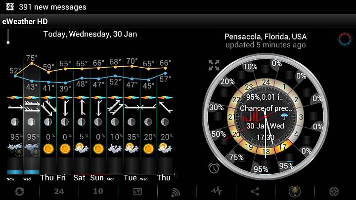
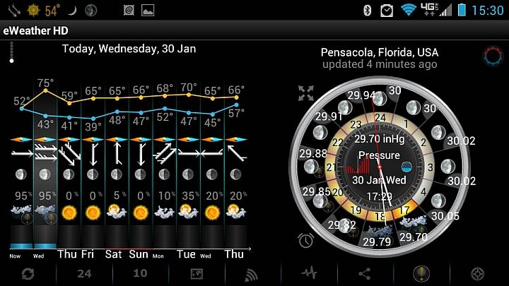
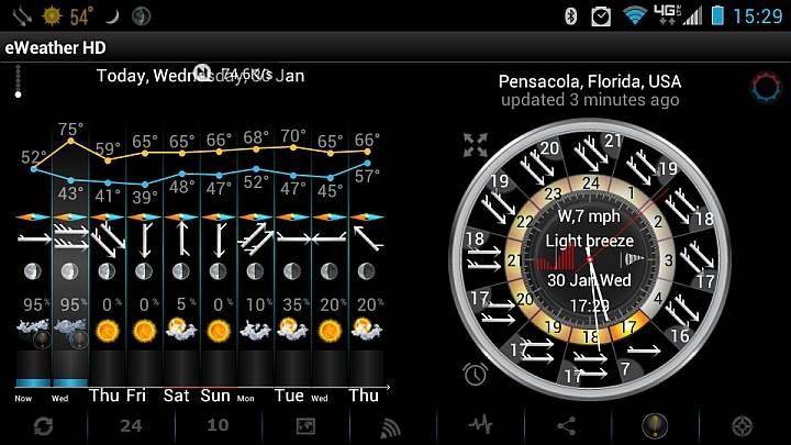
I looked up you all's weather on the Wx app I have on my phone, which has proven to be very accurate out West and in Kansas as well. Here are a couple of screen shots of what this evening, early tomorrow morning is expected to bring you all, plus the Wx Alert for the area:

% Precipitation:
use this to know exactly when the heavy rain is about to hit where you're located 30Jan2013_PNSWx_Precip

Pressure:
use this to know exactly when the heavy rain is about to hit where you're located 30Jan2013_PNSWx_Pressure

Wind:
use this to know exactly when the heavy rain is about to hit where you're located 30Jan2013_PNSWx_Wind

WIND ADVISORY:
From: 30 Jan,Wed 15:18
To: 30 Jan,Wed 21:00
...WIND ADVISORY REMAINS IN EFFECT UNTIL 9 PM CST THIS EVENING...
* TIMING...THROUGH EARLY THIS EVENING.
* WINDS...WEST 15 TO 25 MPH...WITH FREQUENT GUSTS OVER 30 MPH.
* IMPACTS...WINDS THIS STRONG CAN MAKE DRIVING DIFFICULT...
ESPECIALLY FOR HIGH PROFILE VEHICLES. LOOSE...UNSECURED
OBJECTS CAN ALSO BE BLOWN AROUND.
PRECAUTIONARY/PREPAREDNESS ACTIONS...
A WIND ADVISORY MEANS THAT WIND GUSTS OF 25 TO 39 MPH ARE EXPECTED.
WINDS THIS STRONG CAN MAKE DRIVING DIFFICULT... ESPECIALLY FOR HIGH PROFILE VEHICLES. USE EXTRA CAUTION.
&&
* ISSUED AT: 318 PM CST WED JAN 30
* ISSUED FOR:
INLAND ESCAMBIA-COASTAL ESCAMBIA-INLAND SANTA ROSA-
COASTAL SANTA ROSA-INLAND OKALOOSA-COASTAL OKALOOSA-
INCLUDING THE CITIES OF...CENTURY...FLOMATON...MOLINO...
FERRY PASS...BRENT...WEST PENSACOLA...BELLVIEW...ENSLEY...
MYRTLE GROVE...JAY...PACE...MILTON...CRESTVIEW...WRIGHT...
NICEVILLE...SEMINOLE...EGLIN AFB

Sent from: http://market.android.com/details?id=com .Elecont.WeatherClock - eWeather HD

Likely not much news to many of you, but I always try to look out for my buddies in the Pensacola area.

Oh and for anyone with an Android-based phone, this is absolutely hands-down the best wx app you can get. Trust me, I've tried them all. It is the only app I have ever paid for (after a free trial period, of course), and is worth every penny and more of the $1.99 or whatever I spent for it. I do not recall if they have it for iPhones and whatnot.

Be safe out there!

Sponsored content


Back to top  Message [Page 1 of 1]

Permissions in this forum:
You cannot reply to topics in this forum